Key Highlights
- New York City's Local Law 124 (2024) requires forward-looking flood risk mapping, identifying the Financial District as a high-risk area for climate-related flooding.
- The Lower Manhattan Coastal Resiliency (LMCR) Project has secured $1.7 billion in government funding to build coastal flood defenses across Lower Manhattan.
- Financial District businesses can still provide input on the LMCR Master Plan, and companies can conduct their own climate risk assessments in parallel with public projects.
As sea levels rise and precipitation intensifies, climate-related flood risks threaten many areas of New York City due to its location at the southern end of the Hudson River, an estuary that leads into the Atlantic Ocean.
The New York City Economic Development Corporation (NYCEDC) and the Mayor’s Office of Climate and Environmental Justice (MOCEJ), which lead sustainability planning for the City, aim to mitigate these flood risks while also taking the opportunity to improve public spaces. Many flood preparation projects are in the early planning phases, which gives NYC-based business owners a chance to provide input based on their operational needs and linkages with any climate resilience measures they have initiated on their own.
This article reviews resources and project plans issued by the NYC government in its efforts to address flood risks. It focuses particularly on plans for the Financial District in Lower Manhattan, how businesses can get involved in these projects, and ways to assess how flood risk affects their business.
NYC’s Approach to Flood Preparations: Local Law 124 and Lower Manhattan Coastal Resiliency Project
Much of the planning for local flood mitigation is being shaped by NYC Local Law 124, enacted in 2024. This piece of legislation mandates that the City of New York maintain forward-looking flood risk mapping, reflecting flooding caused by both rising sea levels and rainfall patterns. The City’s planning department has created an Interim Flood Risk Mapper to capture potential risk areas. The map shows flood risk throughout the city based on a ten-year rainfall flood risk, and includes an additional 50-foot-wide area around the expected risk areas to account for the uncertainty of these projections. The City uses the map to identify at-risk areas and plan appropriate mitigation efforts.
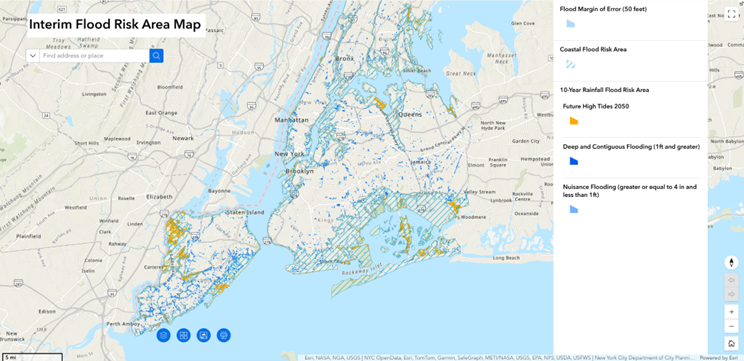
Image credit: NYC Interim Flood Risk Mapper
As seen in the map, large portions of the city are at risk of flooding in the next ten years, including the Financial District.
In response to this risk projection, the City has developed specialized flood management projects for high-risk areas. The Lower Manhattan Coastal Resiliency (LMCR) Project, led jointly by the NYCEDC and MOCEJ, has several coastal resiliency projects underway in Lower Manhattan. These projects include the:
- Brooklyn Bridge-Montgomery Coastal Resilience
- Seaport Coastal Resilience
- The Battery Coastal Resilience
- Battery Park City Resilience Projects (South, North & West)
- Interim Flood Protection Measures (IFPM)
The City, State, and federal governments have committed $1.7B in capital investments to these projects so far, with contributions reflecting the City’s view on the importance of flood risk mitigation.
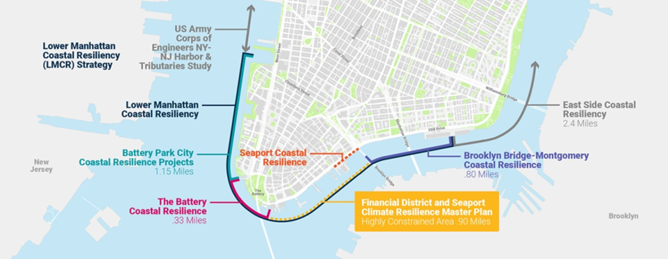
Image credit: NYCEDC Lower Manhattan Coastal Resiliency
These projects are not without criticism, with the expansive nature of the upgrades causing some to question whether all of the stated improvements are necessary or beneficial. This has resulted in a host of lawsuits, primarily about the disruption caused by construction and environmental impacts. The City has won most of these cases, but some are still pending and the public discussion on potential alternative approaches continues.
Strategies for the Financial District
Businesses with operations in the Financial District also should be aware of another LMCR Project workstream, the Financial District and Seaport Climate Resilience Master Plan.
According to the Plan, direct economic impacts to businesses in the area could amount to $8.4B by 2100 without new flood mitigation efforts. To address this need, the City intends to deploy several strategies for flood mitigation, while also improving public spaces.
The Plan is continuously updated, and these projects are still in the planning stages. The City has encouraged local businesses to provide their input on how these projects are carried out. Companies located in the Financial District may want to pay special attention to details like new traffic patterns and a new multi-level waterfront, all described below.
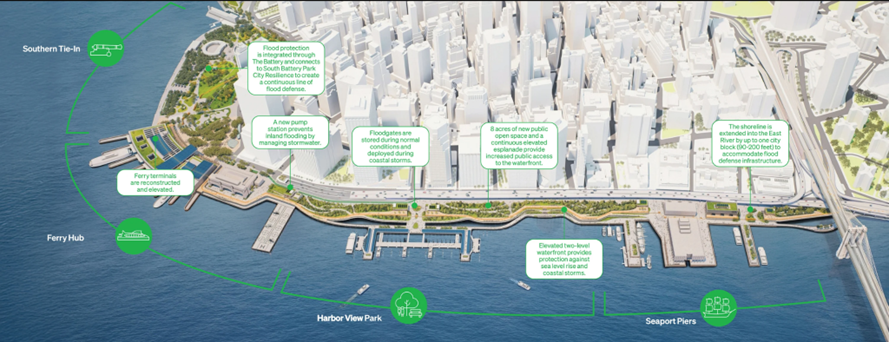
Image credit: Moving FiDi-Seaport Forward
Southern Tie-In: Conceived as a park-like feature to support existing ecosystems, the Southern Tie-In would serve as a bridge between the LMCR project and the adjacent South Battery Park City Resiliency project at Bowling Green, creating a continuous line of flood prevention around Lower Manhattan. During flooding, the park would function as a bioswale, preventing water from reaching the rest of the city.
The Plan includes a floodwall to be built beneath the park. This avoids disturbing existing underground infrastructure or constructing a wall to keep water out of the park. The underground floodwall will create a gentle slope, shaping the land to prevent flooding to the rest of the city while protecting assets such as the Seaglass Carousel, the Urban Farm, and the Battery Playscape.
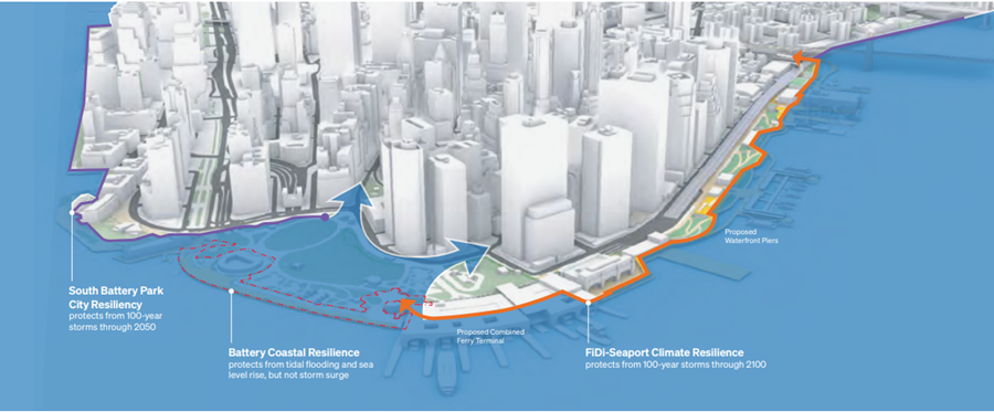
Image credit: Moving FiDi-Seaport Forward
Ferry hub: An essential part of the Plan is to retain waterfront access even while protecting the city. A new combined ferry terminal would replace both the Staten Island and Governors Island Ferry hubs, and it would be elevated to avoid disruptions to service.
The Downtown Skyport will also be elevated, while the historic Battery Maritime Building will be preserved and protected against flooding. The plans also provide for a new public plaza near the Battery Maritime Building, creating a cap over the Battery Underpass to improve pedestrian access.
In addition, a new vehicle access loop will be integrated within the Ferry Hub building to divert traffic away from Peter Minuit Plaza, further improving pedestrian safety while aiding traffic congestion.
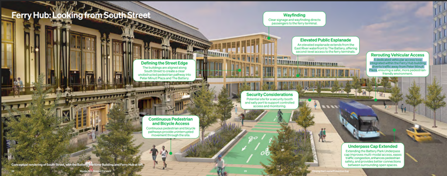
Image credit: Moving FiDi-Seaport Forward
Harbor View Park: A proposed multilevel waterfront will extend the shoreline of the East River by up to 200 feet from its current location. The upper level will be elevated by 15-18 feet to protect against severe storms, while doubling as public spaces overlooking the city and harbor, potentially providing new economic opportunities.
The lower level will be a continuous waterfront esplanade, raised up to five feet to protect against rising water levels while still allowing access to the water’s edge.
The Wall Street/Pier 11 ferry landing will be rebuilt with more space to support ferry services. The City has also proposed installing flood gates and walls to offer additional flood protection in this area.
Current designs pose the idea of rolling flood gates, which would remain open most of the time and only close during coastal storms, to avoid obstructing views of the water.
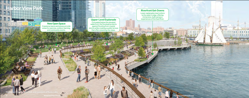
Image credit: Moving FiDi-Seaport Forward
Seaport Piers: Throughout the Lower Manhattan Coastal Resiliency project, preserving historical uses of sites is of utmost importance. These include Pier 16, which will be elevated, and Pier 15, which will be replaced by a new Pier 19 further north. The design will also integrate docks for historic vessels near Pier 17.
Floodgates in this area will provide direct access to the water from the city and provide protection during times of flooding.
In addition, a new small cove by the Brooklyn Bridge could create recreational and economic opportunities.
This project will be connected to the adjacent Brooklyn Bridge-Montgomery Coastal Resilience project with a floodwall, enhancing protections around Lower Manhattan.
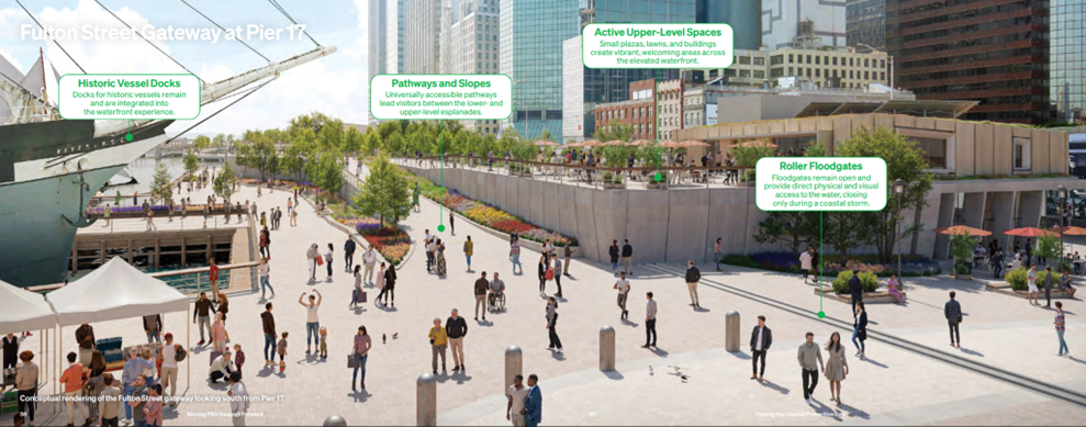
Image credit: Moving FiDi-Seaport Forward
Business’ Window to Respond
The development of this project offers New York City both an opportunity to mitigate severe climate impacts and a new way to spur the development of public spaces and economic opportunities.
For businesses with operations in the Financial District or other parts of Lower Manhattan, officials are still collecting input, so you have a chance to shape how the City handles flood mitigation. Interested parties can submit comments and review past events/materials related to the project on the NYC Lower Manhattan Coastal Resiliency website.
Companies can also benefit from taking action in parallel to public projects, in particular by conducting their own climate risk mapping to determine vulnerabilities and areas of opportunity. The G&A Institute’s Climate Risks & Opportunities Assessment provides a pathway for companies to begin this process with expert guidance.

Build your sustainability strategy.
Founded in 2006, Governance & Accountability Institute (G&A) is a New York–based sustainability consulting and research firm advising corporate leaders and investors at the intersection of strategy, governance, and regulation. For two decades, we have partnered with executive teams and boards to translate sustainability strategy into durable enterprise value — helping organizations navigate shifting market expectations, evolving policy landscapes, and increasing capital markets scrutiny. Set up a call to learn more about how we can help your company.


Share This Article
 How Can G&A Help?
Build your sustainability strategy.
Chat with our experts to get started on your journey.
Get Started